<?xml version="1.0" encoding="utf-8"?><feed xmlns="http://www.w3.org/2005/Atom" ><generator uri="https://jekyllrb.com/" version="3.10.0">Jekyll</generator><link href="https://v4rl-ucy.github.io/feed.xml" rel="self" type="application/atom+xml" /><link href="https://v4rl-ucy.github.io/" rel="alternate" type="text/html" /><updated>2026-05-18T09:53:13+00:00</updated><id>https://v4rl-ucy.github.io/feed.xml</id><title type="html">Vision for Robotics Lab (V4RL)</title><subtitle>Website for V4RL student projects
</subtitle><author><name>Professor Margarita Chli</name></author><entry><title type="html">Continuous-Time Multi-Sensor Odometry in the Wild</title><link href="https://v4rl-ucy.github.io/2025/10/13/ct.html" rel="alternate" type="text/html" title="Continuous-Time Multi-Sensor Odometry in the Wild" /><published>2025-10-13T00:00:00+00:00</published><updated>2025-10-13T00:00:00+00:00</updated><id>https://v4rl-ucy.github.io/2025/10/13/ct</id><content type="html" xml:base="https://v4rl-ucy.github.io/2025/10/13/ct.html"><![CDATA[<p>The goal of this project is to develop a robust, continuous-time multi-sensor odometry system that can handle multi-rate synchronization.</p>

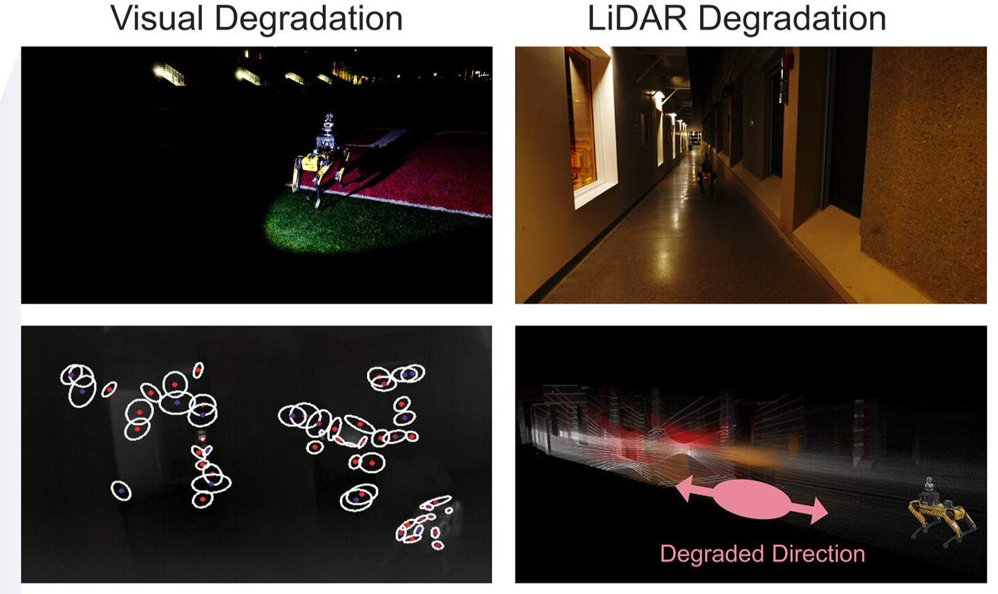
<p><img src="/assets/ct.png" alt="" />
<em>Odometry degradation scenarios shown in [4]</em></p>

<hr />

<h2 id="background">Background</h2>

<p>Multi-sensor odometry estimates a robot’s full 6-DoF pose by fusing complementary data streams—cameras, LiDAR, IMU, and GNSS—each sampled at its own rate. Representing motion as a continuous-time trajectory, rather than as a sequence of discrete poses, simplifies multi-rate synchronization [1,2]. Each modality breaks down under different conditions: visual–inertial odometry drifts during rapid rotations, abrupt illumination changes, or texture-poor scenes, while LiDAR–inertial odometry loses observability in geometrically featureless environments. Recent work [1] proposes a fusion strategy for robust odometry, but it still relies on tightly synchronized sensors.</p>

<hr />

<h2 id="description">Description</h2>

<p>Real robots don’t live in perfect lab conditions. So how do we estimate motion when sensors are noisy, unsynchronized, and running at different speeds? This project takes a modern approach by modelling motion in continuous time, allowing seamless fusion of camera, LiDAR, and IMU data. You’ll explore trajectory optimization, time alignment, and multi-sensor calibration, building systems that perform reliably “in the wild.” This is a great fit if you enjoy combining math, coding, and real-world experimentation to push the limits of state estimation.</p>

<hr />

<h2 id="work-packages">Work Packages</h2>

<ul>
  <li>Literature review of work on multi-sensor odometry</li>
  <li>Literature review of work on continuous-time trajectory</li>
  <li>Design a multi-sensor fusion strategy</li>
  <li>Evaluate the performance of the approach in comparison with existing work</li>
</ul>

<hr />

<h2 id="requirements">Requirements</h2>

<ul>
  <li>Experience with C++ and ROS</li>
</ul>

<hr />

<h2 id="references">References</h2>

<ul>
  <li>[1] Cioffi, G., Cieslewski, T., &amp; Scaramuzza, D., “Continuous-time vs. discrete-time vision-based SLAM: A comparative study”, IEEE Robotics and Automation Letters,  2022.</li>
  <li>[2] Hug, David, Ignacio Alzugaray, and Margarita Chli., “Hyperion–A Fast, Versatile Symbolic Gaussian Belief Propagation Framework for Continuous-Time SLAM”, European Conference on Computer Vision. Cham: Springer Nature Switzerland, 2024.</li>
  <li>[3] C. Zheng et al., “FAST-LIVO2: Fast, Direct LiDAR-Inertial-Visual Odometry”, IEEE Transactions on Robotics, 2024.</li>
  <li>[4] Zhao, Shibo, et al., “Resilient odometry via hierarchical adaptation”, Science Robotics 10.109, 2025.</li>
</ul>]]></content><author><name>Professor Margarita Chli</name></author><summary type="html"><![CDATA[The goal of this project is to develop a robust, continuous-time multi-sensor odometry system that can handle multi-rate synchronization.]]></summary></entry><entry><title type="html">Odometry and Mapping in Dynamic Environments</title><link href="https://v4rl-ucy.github.io/2025/10/13/dynamic.html" rel="alternate" type="text/html" title="Odometry and Mapping in Dynamic Environments" /><published>2025-10-13T00:00:00+00:00</published><updated>2025-10-13T00:00:00+00:00</updated><id>https://v4rl-ucy.github.io/2025/10/13/dynamic</id><content type="html" xml:base="https://v4rl-ucy.github.io/2025/10/13/dynamic.html"><![CDATA[<p>The goal of this project is to develop a lidar-inertial odometry approach that tightly integrates dynamic object filtering into the pose estimation and mapping pipeline.</p>

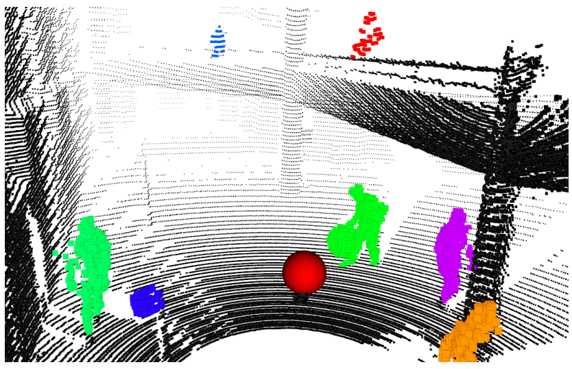
<p><img src="/assets/dynablox.png" alt="" />
<em>Detecting dynamic objects in a 3D map using Dynablox [2]</em></p>
<hr />

<h2 id="background">Background</h2>

<p>Existing lidar-inertial odometry approaches (e.g., FAST-LIO2 [1]) are capable of providing sufficiently accurate pose estimation in structured environments to capture high quality 3D maps of static structures in real-time. However, the presence of dynamic objects in an environment can reduce the accuracy of the odometry estimate and produce noisy artifacts in the captured 3D map. Existing approaches to handling dynamic objects [2-4] focus on detecting and filtering them from the captured 3D map but typically operate independently from the odometry pipeline, which means that the dynamic filtering does not improve the pose estimation accuracy.</p>

<hr />

<h2 id="description">Description</h2>

<p>How do robots navigate busy, ever-changing environments without getting confused by moving people, cars, or objects? In this project, you’ll build a system that fuses LiDAR (3D laser scans) and IMU data to estimate motion and create maps in real time, even when the world around the robot won’t stay still. You’ll dive into point cloud processing, sensor fusion, and dynamic object filtering, developing algorithms that can distinguish what’s static from what’s moving. If you’re interested in autonomous vehicles, drones, or real-world robotics challenges, this is your chance to work on SLAM systems that don’t break in the real world.</p>

<hr />

<h2 id="work-packages">Work Packages</h2>

<ul>
  <li>Literature review of work on lidar-inertial odometry and dynamic object detection</li>
  <li>Develop a lidar-inertial odometry approach that can robustly handle dynamic environments</li>
  <li>Evaluate the performance of the approach in comparison with existing work</li>
</ul>

<hr />

<h2 id="requirements">Requirements</h2>

<ul>
  <li>Experience with C++ and ROS</li>
</ul>

<hr />

<h2 id="references">References</h2>

<ul>
  <li>[1] W. Xu, Y. Cai, D. He, J. Lin, and F. Zhang, “FAST-LIO2: Fast Direct LiDAR-inertial Odometry,” arXiv, 2021.</li>
  <li>[2] L. Schmid, O. Andersson, A. Sulser, P. Pfreundschuh, and R. Siegwart, “Dynablox: Real-Time Detection of Diverse Dynamic Objects in Complex Environments,” IEEE Robotics and Automation Letters, 2023.</li>
  <li>[3] D. Duberg, Q. Zhang, M. Jia, and P. Jensfelt, “DUFOMap: Efficient Dynamic Awareness Mapping,” IEEE Robotics and Automation Letters, 2024.</li>
  <li>[4] H. Lim, S. Hwang, and H. Myung, “ERASOR: Egocentric Ratio of Pseudo Occupancy-based Dynamic Object Removal for Static 3D Point Cloud Map Building,” IEEE Robotics and Automation Letters, 2021.</li>
</ul>]]></content><author><name>Professor Margarita Chli</name></author><summary type="html"><![CDATA[The goal of this project is to develop a lidar-inertial odometry approach that tightly integrates dynamic object filtering into the pose estimation and mapping pipeline.]]></summary></entry><entry><title type="html">LiDAR-Visual-Inertial Odometry with a Unified Representation</title><link href="https://v4rl-ucy.github.io/2025/10/13/lvi.html" rel="alternate" type="text/html" title="LiDAR-Visual-Inertial Odometry with a Unified Representation" /><published>2025-10-13T00:00:00+00:00</published><updated>2025-10-13T00:00:00+00:00</updated><id>https://v4rl-ucy.github.io/2025/10/13/lvi</id><content type="html" xml:base="https://v4rl-ucy.github.io/2025/10/13/lvi.html"><![CDATA[<p>The goal of this project is to develop a lidar-visual-inertial odometry approach that integrates visual and lidar measurements into a single unified representation.</p>

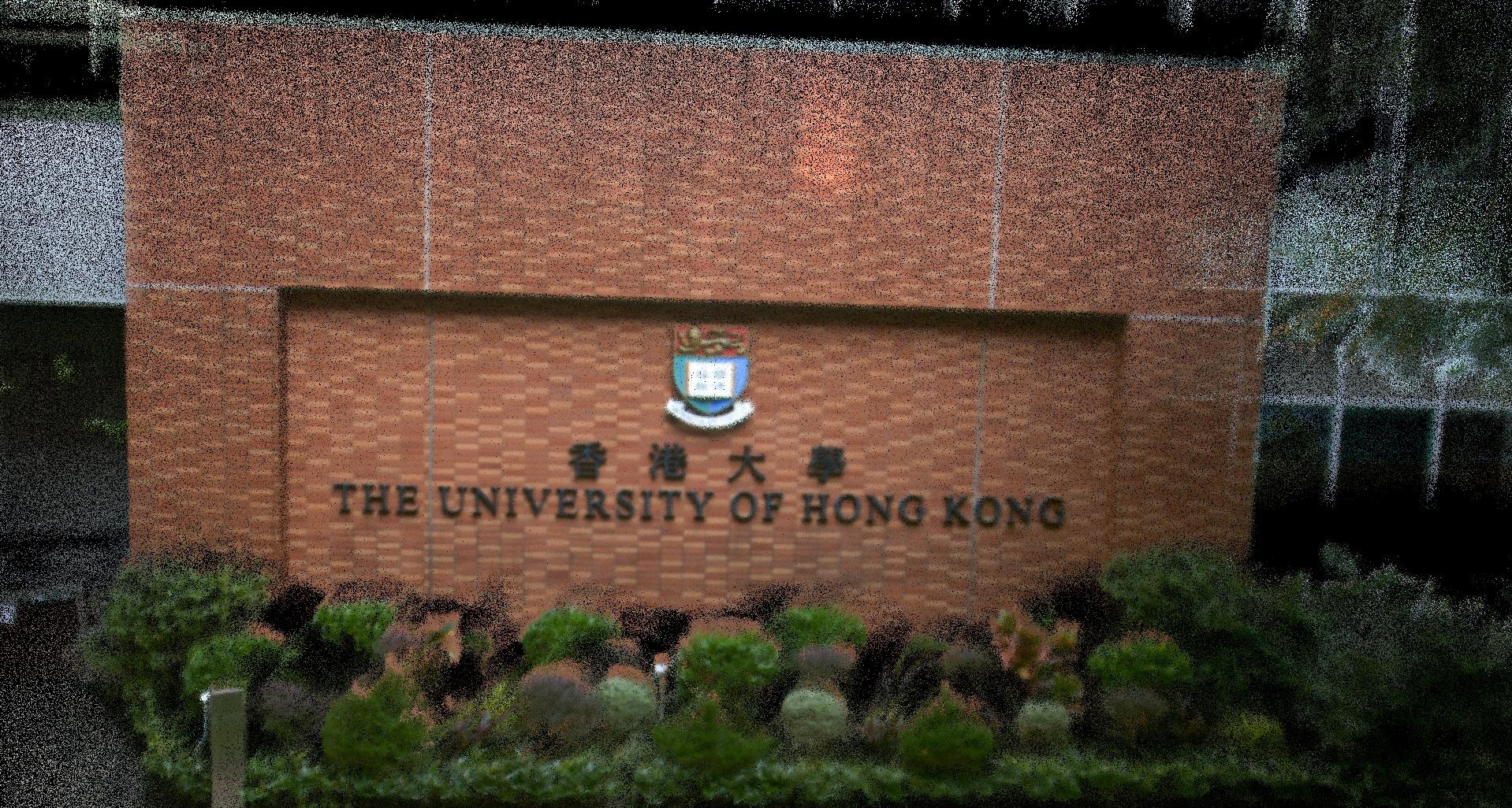
<p><img src="/assets/fast-livo2.jpg" alt="" />
<em>The output of FAST-LIVO2 [1], a state-of-the-art LiDAR-Visual-Inertial mapping approach</em></p>
<hr />

<h2 id="background">Background</h2>

<p>LiDAR-Visual-Inertial odometry approaches [1-3] aim to overcome the limitations of the individual sensing modalities by estimating a pose from heterogenous measurements. Lidar-inertial odometry often diverges in environments with degenerate geometric structures and visual-inertial odometry can diverge in environments with uniform texture. Many existing lidar-visual-inertial odometry approaches use independent lidar-inertial and visual-inertial pipelines [2-3] to compute odometry estimates that are combined in a joint optimisation to obtain a single pose estimate. These approaches are able to obtain a robust pose estimate in degenerate environments but often underperform lidar-inertial or visual-inertial methods in non-degenerate scenarios due to the complexity of maintaining and combining odometry estimates from multiple representations.</p>

<hr />

<h2 id="description">Description</h2>

<p>In this project, you’ll help a robot build a single, super-powered sense of its surroundings. Instead of having the camera and the 3D laser (LiDAR) work separately, you’ll develop a way to “glue” them together. You’ll take images from a camera and align them with 3D shapes that the laser detects. The goal? To create a navigation system that is faster, more accurate, and harder to confuse than what is used today.</p>

<hr />

<h2 id="work-packages">Work Packages</h2>

<ul>
  <li>Literature review of work on lidar-visual-inertial odometry</li>
  <li>Develop a lidar-visual-inertial odometry approach with a single unified representation</li>
  <li>Evaluate the performance of the approach in comparison with existing work</li>
</ul>

<hr />

<h2 id="requirements">Requirements</h2>

<ul>
  <li>Experience with C++ and ROS</li>
</ul>

<hr />

<h2 id="references">References</h2>

<ul>
  <li>[1] C. Zheng et al., “FAST-LIVO2: Fast, Direct LiDAR-Inertial-Visual Odometry,” IEEE Transactions on Robotics, 2024.</li>
  <li>[2] J. Lin and F. Zhang, “R3LIVE++: A Robust, Real-time, Radiance reconstruction package with a tightly-coupled LiDAR-Inertial-Visual state Estimator,” IEEE Transactions on Pattern Analysis and Machine Intelligence, 2024.</li>
  <li>[3] T. Shan, B. Englot, C. Ratti, and D. Rus, “LVI-SAM: Tightly-coupled Lidar-Visual-Inertial Odometry via Smoothing and Mapping,” in IEEE International Conference on Robotics and Automation, 2021.</li>
  <li>[4] W. Xu, Y. Cai, D. He, J. Lin, and F. Zhang, “FAST-LIO2: Fast Direct LiDAR-inertial Odometry,” arXiv, 2021.</li>
</ul>]]></content><author><name>Professor Margarita Chli</name></author><summary type="html"><![CDATA[The goal of this project is to develop a lidar-visual-inertial odometry approach that integrates visual and lidar measurements into a single unified representation.]]></summary></entry><entry><title type="html">Versatile, Robust and Simulatable Multi-Robot SLAM</title><link href="https://v4rl-ucy.github.io/2025/10/13/multirobot.html" rel="alternate" type="text/html" title="Versatile, Robust and Simulatable Multi-Robot SLAM" /><published>2025-10-13T00:00:00+00:00</published><updated>2025-10-13T00:00:00+00:00</updated><id>https://v4rl-ucy.github.io/2025/10/13/multirobot</id><content type="html" xml:base="https://v4rl-ucy.github.io/2025/10/13/multirobot.html"><![CDATA[<p>This project aims to develop multi-robot SLAM capabilities able to perform in such challenging, real environments, forming the basis of navigation autonomy and coordination of a swarm of drones.</p>

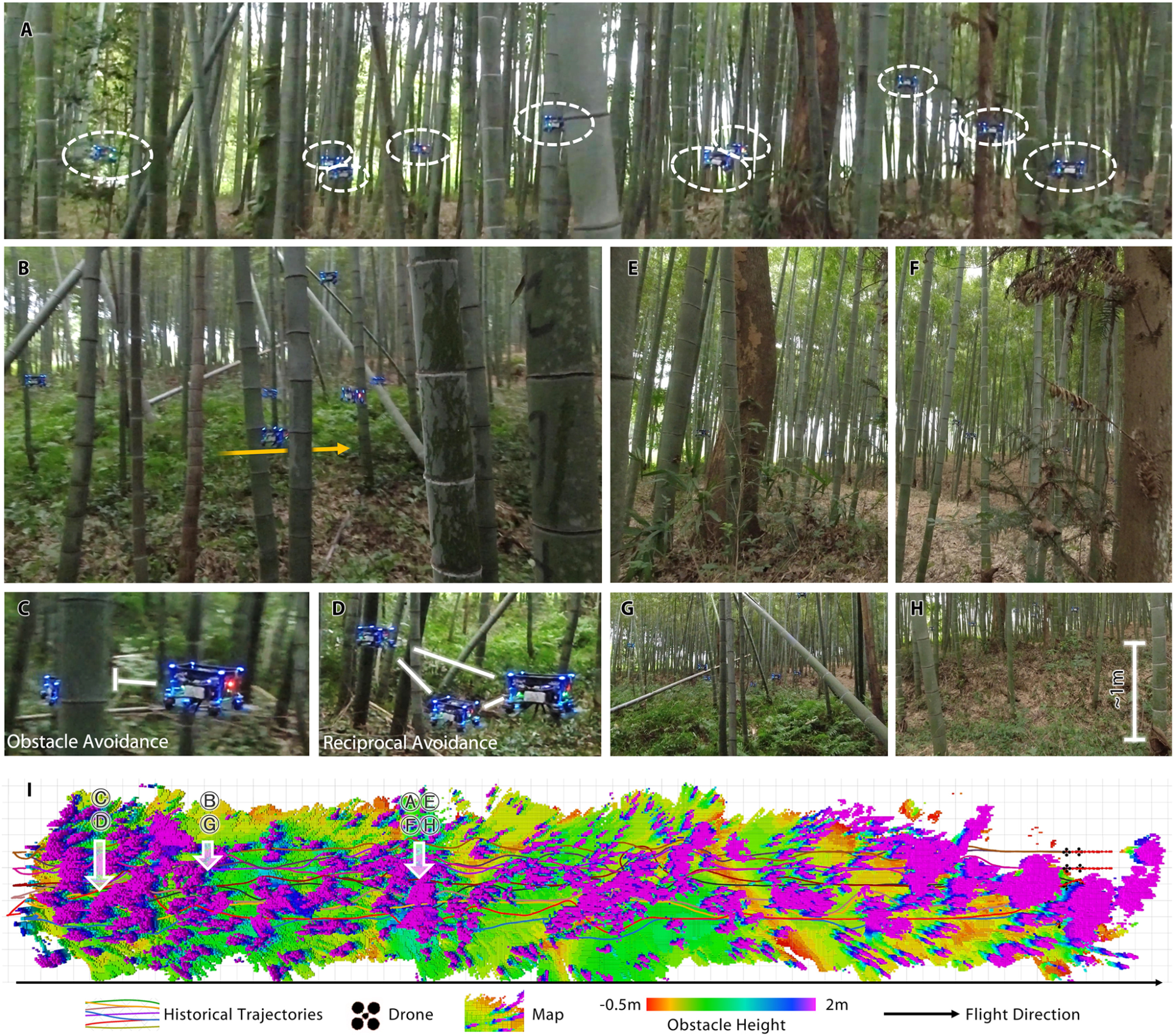
<p><img src="/assets/multirobot.png" alt="" />
<em>Mapping and navigation of a drone swarm in a clustered forest area [1]</em></p>
<hr />

<h2 id="background">Background</h2>

<p>Recent work on multi-robot systems with collaborative autonomy has made significant strides towards developing robotic teams capable of performing complex tasks in real, complex settings as shown above. Right at the core of such capabilities is the capability to collaboratively perform SLAM (Simultaneous Localization And Mapping) within such multi-agent systems that can operate efficiently and in challenging real-world environments, which is the main goal of this project.</p>

<hr />

<h2 id="description">Description</h2>

<p>What’s better than one robot mapping the world? A whole team doing it together. This project explores how multiple robots can collaborate to localize themselves and build a shared map, both in simulation and real-world scenarios. You’ll work on multi-agent SLAM, communication strategies, and map merging, tackling challenges like consistency and scalability as more robots join the system. The project combines theory with hands-on experimentation, making it perfect if you’re excited by robot swarms, distributed systems, or search-and-rescue applications where teamwork is key.</p>

<hr />

<h2 id="work-packages">Work Packages</h2>

<ul>
  <li>The work packages of this project involves, literature review of existing research on multi-robot SLAM, develop new SLAM algorithms for identified challenges, and validate algorithms in simulation and with real-world experiments</li>
</ul>

<hr />

<h2 id="requirements">Requirements</h2>

<ul>
  <li>The students taking this project need to have programming experience with Python and C++, ROS and/or ROS 2</li>
</ul>

<hr />

<h2 id="references">References</h2>

<ul>
  <li>[1] Zhou, Xin, et al. “Swarm of micro flying robots in the wild.” Science Robotics 7.66 (2022): eabm5954.</li>
</ul>]]></content><author><name>Professor Margarita Chli</name></author><summary type="html"><![CDATA[This project aims to develop multi-robot SLAM capabilities able to perform in such challenging, real environments, forming the basis of navigation autonomy and coordination of a swarm of drones.]]></summary></entry><entry><title type="html">Photorealistic and Semantic 3D Scene Representation for Visual SLAM</title><link href="https://v4rl-ucy.github.io/2025/10/13/semantic.html" rel="alternate" type="text/html" title="Photorealistic and Semantic 3D Scene Representation for Visual SLAM" /><published>2025-10-13T00:00:00+00:00</published><updated>2025-10-13T00:00:00+00:00</updated><id>https://v4rl-ucy.github.io/2025/10/13/semantic</id><content type="html" xml:base="https://v4rl-ucy.github.io/2025/10/13/semantic.html"><![CDATA[<p>This project aims to develop a semantically-aware, photorealistic SLAM system capable of constructing dense 3D maps that bridge the gap between geometric reconstruction and scene understanding to enhance autonomous robotic perception.</p>

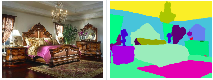
<p><img src="/assets/semantics.png" alt="" />
<em>Semantic segmentation in an indoor environment</em></p>

<hr />

<h2 id="background">Background</h2>

<p>Simultaneous Localization and Mapping (SLAM) is the foundation of robotic autonomy, requiring the concurrent estimation of a robot’s pose and the construction of its surrounding environment. While traditional SLAM frameworks focus on geometric primitives, they often lack the “semantic awareness” needed for complex decision-making. Recent advancements in dense 3D reconstruction and deep learning-based segmentation offer a path toward photorealistic maps that are also semantically labeled. However, accurately fusing high-dimensional visual features with spatial geometry remains a significant challenge, especially when aiming for real-time performance and high-fidelity representations.</p>

<hr />

<h2 id="description">Description</h2>

<p>How does a robot distinguish a navigable hallway from a glass wall, or a pedestrian from a static statue? This project moves beyond simple point clouds to develop semantically rich, photorealistic 3D maps. You will integrate state-of-the-art segmentation models with dense SLAM pipelines to create environments where every pixel has both a coordinate and a meaning. The work involves exploring deep-learning architectures, spatial data fusion, and large-scale scene representation. This project is ideal for those interested in the intersection of Computer Vision and Robotics, offering the chance to build intelligent systems that truly understand the world they inhabit.</p>

<hr />

<h2 id="work-packages">Work Packages</h2>

<ul>
  <li>The work will focus on state-of-the-art radiance field models and semantic segmentation methods, and on evaluating the resulting system across diverse environments.</li>
</ul>

<hr />

<h2 id="requirements">Requirements</h2>

<ul>
  <li>The students taking this project need to have programming experience with Python and C++</li>
</ul>

<hr />

<h2 id="references">References</h2>]]></content><author><name>Professor Margarita Chli</name></author><summary type="html"><![CDATA[This project aims to develop a semantically-aware, photorealistic SLAM system capable of constructing dense 3D maps that bridge the gap between geometric reconstruction and scene understanding to enhance autonomous robotic perception.]]></summary></entry></feed>